Search This Blog

Sunday, November 14, 2010

Day 19: Bluff, Utah day 1: hike to Moonhouse

After a good night's rest and a quick review of the weather, we decided to stay another night at the Desert Rose Inn. We got ready at a leisurely pace before heading out for our first hike. We were armed with detailed maps and incredible directions from Drew and Carrie. The sites that Drew and Carrie recommended are not on the maps, and they’re not marked with trailheads either. They seem to be passed on through word of mouth. Luckily, Drew and Carrie thought we were cool enough to get to these incredible ruins, and so shared their maps and information.
We drove out to the BLM land, which is huge. It had a paved main highway through it with all of these dirt roads or paths shooting out from it. Some were labeled some were not. The paved road turned into a dirt road through the mountain climbs. The views were stunning; the rocky mountains and canyons seemed to go on forever.


After about 20 miles on the main road, we turned off onto a bumpy dirt road. 4-wheel drive seems like it would be mandatory out here. Drew said to avoid the roads when they were wet, and you could see why. The rocks and red dirt could really turn slick. Despite growing up in Colorado, and so having plenty of snow driving experience, Drew said he slid Carrie’s Subaru 30 feet in the rain.


We followed the dirt road for what seemed like a very long time. I think it probably took about an hour to go about 8 miles. We parked in a little pull out, where there happened to be a little podium with a self-pay box and a billboard with a few facts about the area. There clearly is a ruin site near here, as the postings give a few facts about the Basketweaving people who inhabited the area from 1070 to 1200 AD. However, there was nothing on the road or the map to mention this. It seems to be set up so that if you know where you’re going you can find these incredible historical sites.
Before setting out on our hike, we made ourselves a hearty lunch. All of our camping stuff is in the car, so it’s easy to stop off on these deserted roads to cook a meal. We had skipped breakfast, and so had a hearty lunch of salami sandwiches and top ramen soup out there in the open space. There was literally not a soul around; the only evidence of other beings was the coyote tracks.


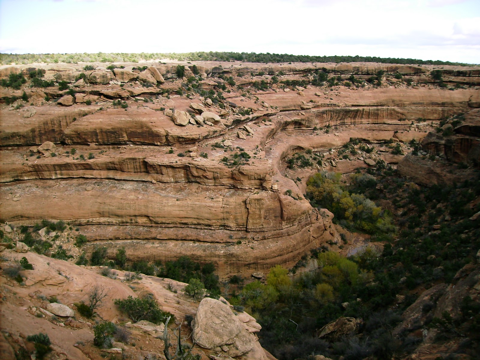
We hiked the flat desert-like landscape for about a mile before we found ourselves at the edge of a canyon.


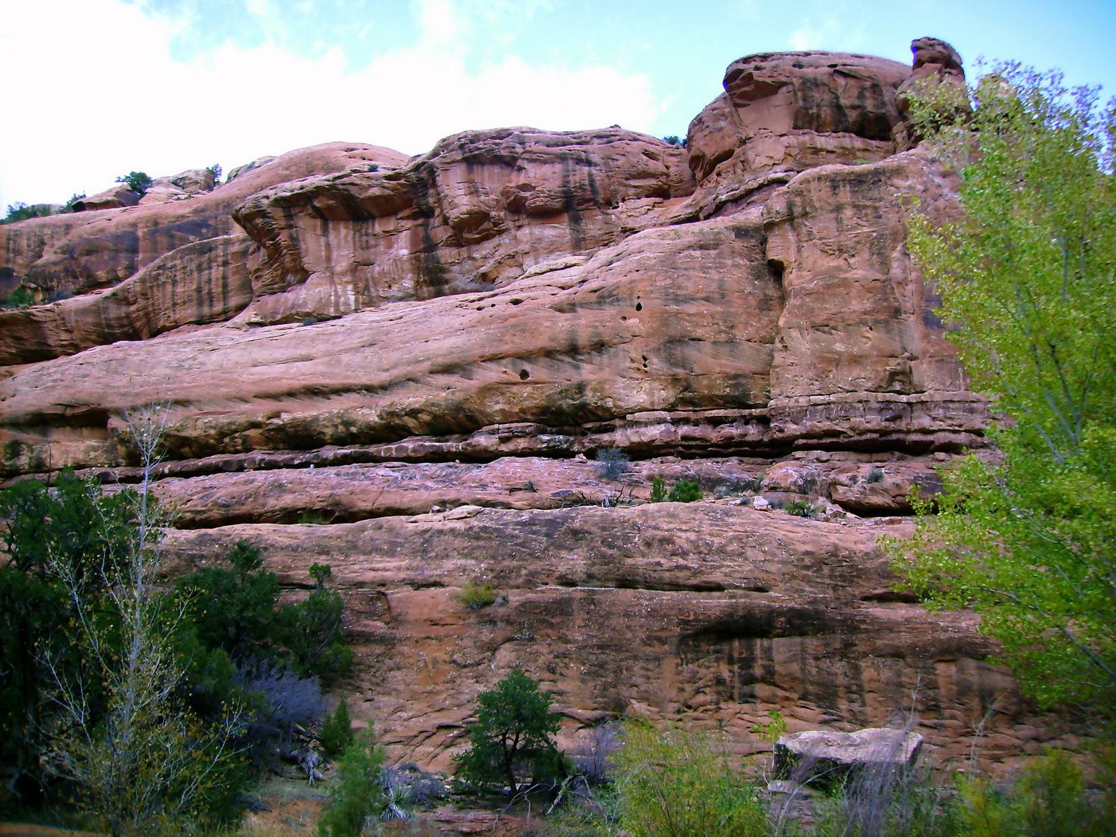
Sure enough, across the canyon were some rock dwellings built into one of the cliff’s layers. Next came the tricky part of the hike: we had to climb down the canyon, cross the ravine, and climb up the other side to view the ruins. Thank God I went to the climbing gym with Clint a few times, the experience gave me a bit more confidence for the descent. As I mentioned before, there was no trail, but we did spot a few cairns (rock stacks) that seemed to be placed at the best places to climb up or down.
Once down, there was only a little bit of water in the ravine, which we easily jumped over.


Finding our way up was harder than we anticipated. We climbed up a tree, which had been used as a ladder, but once up to the first layer, we couldn’t find our way up to the next layer. We had to climb back down and retrace our steps along the water before finding another way to climb up.


I cannot describe how it felt to get up to the ruin, but I suppose I’ll try. It’s so rewarding after a little bit of climbing and hiking to find a pristine site that hasn’t been roped off and surrounded by tons of photo-snapping tourists. We felt like archeologists, and yet the site was a sure thing.


It turns out that we should have obtained a special permit to be out here, but we really had no idea since there weren’t really signs, and there were certainly not people.


Once learning about the permit, we got pretty nervous and so hurried through the site. It gives one hope in humankind to find such an old site in such good condition. No ropes, no entrance fee, no graffiti.
Climbing back up the canyon was easier than the way down, and we made it back to the car without any trouble. It was dark by the time we got back to Bluff, and we opted for a dinner of backpacking macaroni and cheese in our hotel.

Day 18: Zion NP to Bluff, UT

We packed up camp and reorganized our overfilled car without making breakfast. We were eager to get on the road, since we figured our drive would only take 4 or 5 hours. We like to try to get to a place before dark so we can properly check it out and possible get in some exercise. We took several highways: 9 out of Zion to the 89 south, 89 to Page, Arizona, where we picked up 98. We took the 98 to 160, which runs through reservation land, and 160 to 191 north, stopping at Bluff. Sounds like a crazy round-about route, but it really was the most direct path to eastern Utah.


Boy were we wrong in our estimation of time.
We stopped briefly at on overlook to view the Glen Canyon Dam at Lake Powell,
but by then it was past 1 pm and we hadn’t had breakfast or lunch.

Those of you that know us well know that when we get hungry, we get grumpy. And let me tell you, we were in danger zone. We decided to stop in Page for some food since it was the last main city on our route. Any of you ever been to Page? It’s right up there on our list with Idaho Falls. The town seems very depressed. Turns out that it was originally built up when the dam was being constructed. Once the dam was constructed, Page turned into somewhat of a ghost town. A few years later, a power plant went up and so the town became populated again.
We found a burger joint on the main street called R.D.’s Drive Through. We decided it would be best if we stopped for our lunch since our respective blood sugars were so low. The burgers might as well have been from Burger King (Clint says that Burger King would have been better), but the milk shake was good, and so was the break.
We resumed our drve through the desolate reservation land for several more hours. It was dark by the time we reached Bluff. Bluff is a very small town; it is sandwiched between BLM land and Navajo Indian Reservation land. It was so dark when we arrived that we weren’t sure how small, so we jumped at the first hotel opportunity there was - The Desert Rose Inn. After 3 nights of camping, and our 4 hikes, we were pretty rank. We were both in dire need of a shower and a change of clothes. The Desert Rose Inn even had a washer and dryer so we were able to do a load of laundry! After starting a load of our dirty and very stinky clothes, we showered and headed out for dinner. The hotel receptionist pointed us in the direction of the Twin Rocks CafĂ©, which was about a mile from the hotel. The dinner was pretty good, and we were starting to really feel good about Bluff. I had the Navajo taco-a large slab of fry bread (about the size of naan) topped with chile and lettuce and cheese. It was perhaps more of a tostada, but the fry bread was doughy in the middle. I had started with some homemade chicken soup, which was delicious, so I barely made a dent in the large taco. Clint had chicken fried steak with mashed potatoes. It came with a homemade wheat dinner roll, which was the highlight of his meal in my opinion, but he liked it. After dinner, we called it a night.